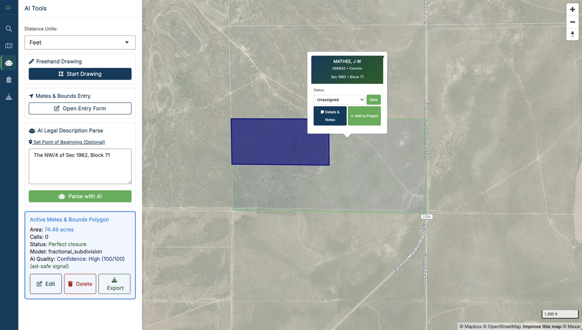
A project workspace for land professionals. Turn deeds, GIS files, and scanned exhibits into persistent, reviewable, exportable project intelligence.
Every boundary in Land Intelligence can tell you where it came from, how it was made, and how much you can trust it.
Paste deed text or upload a PDF or scanned image. AI extracts the calls, walks the traverse, and draws the boundary on the map. The extracted text stays visible the whole time, so you can see exactly what the AI read.
The call grid is fully editable. Fix a bearing or distance and the polygon updates instantly, with no need to re-run the AI. Each call traces back to the deed language it came from, and uncertain parses get flagged for review.
Closure, misclose, precision ratio, and acreage on every check. Curves, commencement-to-POB calls, and the units real Texas deeds use: varas, chains, rods, and links alongside feet and meters.
When you'd rather type the calls yourself, a surveyor-style entry table takes quadrant bearings, cardinal directions, and curve calls. Check closure before you commit, then save the result like any other feature.
Import shapefiles, KML/KMZ, GeoJSON, and CSV. A column and CRS mapper handles odd headers and Texas State Plane coordinates. Leasehold layers, unit outlines, and well spots live alongside your deed plots.
GeoJSON, KML, and shapefile exports that open cleanly in ArcGIS, QGIS, and Google Earth, plus PDF map reports with acreage, closure, and provenance. Your work leaves the platform in the format your client needs.
Most deed plotters hand you a polygon on a blank page. Land Intelligence puts your plot on the Texas survey grid.
The original land survey grid under every plot, so a legal description lands where it should. Fractional section and abstract-based descriptions included.
Land Intelligence comes from the team behind Wells Intelligence. Well, permit, and production layers are planned as optional context under your tracts after launch.
Every boundary keeps its source, method, and confidence, whether it was parsed from a deed, typed from calls, imported from GIS, or drawn by hand.
Run title projects in a web workspace instead of desktop CAD software. Plot deeds, keep every tract organized by project, and hand clients clean exhibits and GIS files.
Work irregular tracts, easements, and corridor descriptions with closure math you can defend, and export PDF exhibits and CAD-ready files for the file room.
Keep a whole deal's geometry in one persistent project: deeds, units, and leasehold together, with the provenance to show where each boundary came from.
The services that power the app are built to ship as a CLI and API, so deed parsing and exports can run in your pipelines and your AI agents' workflows.
Land Intelligence is being built automation-first. The parsing, geometry, and export services behind the app are designed to ship as a CLI and API. An MCP server is on the roadmap so agent clients like Claude Code can plot deeds directly.
$ li project create "Bandera Review" $ li deed parse-text deed.txt --project bandera-review $ li deed walk parse_result.json \ --lat 29.7261 --lng -98.9431 --start-mode pob ok misclose_ft precision acres true 0.03 1:41,000 160.02 $ li export project --project bandera-review --format shapefile
Land Intelligence is in the final stretch before release. Leave your email and you'll be the first to know when it opens up.